 |
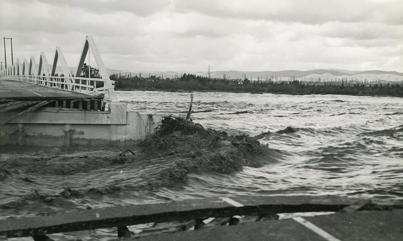
Bridge Out During Flood, 1938
Unknown Photographer; Orange County, California
Photographic print; 10 x 8 in.
34413.13
Gift of Judge Raymond Thompson |
Calm Amidst the Storm
California is right now in a calm between periods of torrential downpours. The fact that the state has been in a drought for almost two decades has made the sudden bursts of rain all the more dangerous as long periods of soil erosion have led to deadly landslides. Tens of thousands across the state have been evacuated from their homes and, worse yet, lives have been lost. Orange County in particular is no stranger to these conditions, however, and flooding here used to be far worse before infrastructure was constructed to contain the worst of weather events with the potential of being naturally disastrous. This post looks at historical flooding in California, especially the flood of 1938, and how infrastructure was put in place to prevent downpours from turning into large-scale floods.
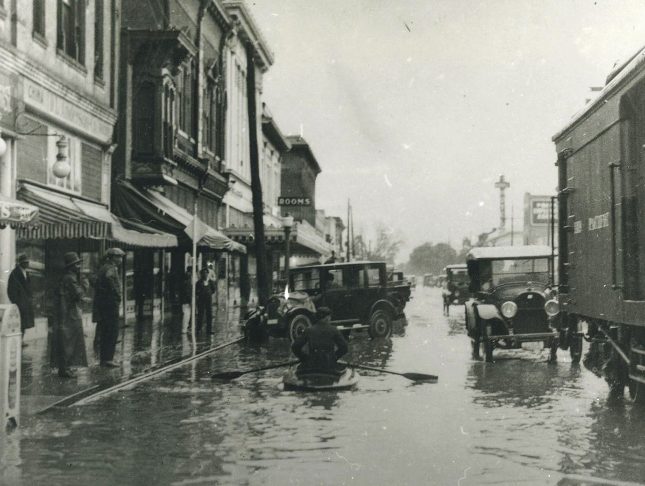 |
Man Canoeing Down a Flooded Street in Santa Ana, 1938
Leo Tiede (American 1898-1968); Santa Ana, California
Photographic print; 5 x 4 in.
37057.309
Leo Tiede Photography Collection |
A Rising Tide Lifts All Boats
California flooding dates back long before the arrival of Spanish settlers to the region. Indigenous oral histories speak of great rainfall events and caution against building settlements in areas prone to flooding. Geological studies have also been able to pinpoint major floods taking place every two to three centuries as far back as the beginning of the common era; the most recent of these prior to the arrival of the Spanish being around 1750. The largest recorded flood to hit California took place between December 1861 and January ’62. It turned the state capital into a system of canals, gondolas, and waterlogged homes to rival the majesty of Venice. The above photograph of an individual with similar sensibilities to those living in Sacramento during California’s Great Flood was snapped in Santa Ana almost 80 years later.
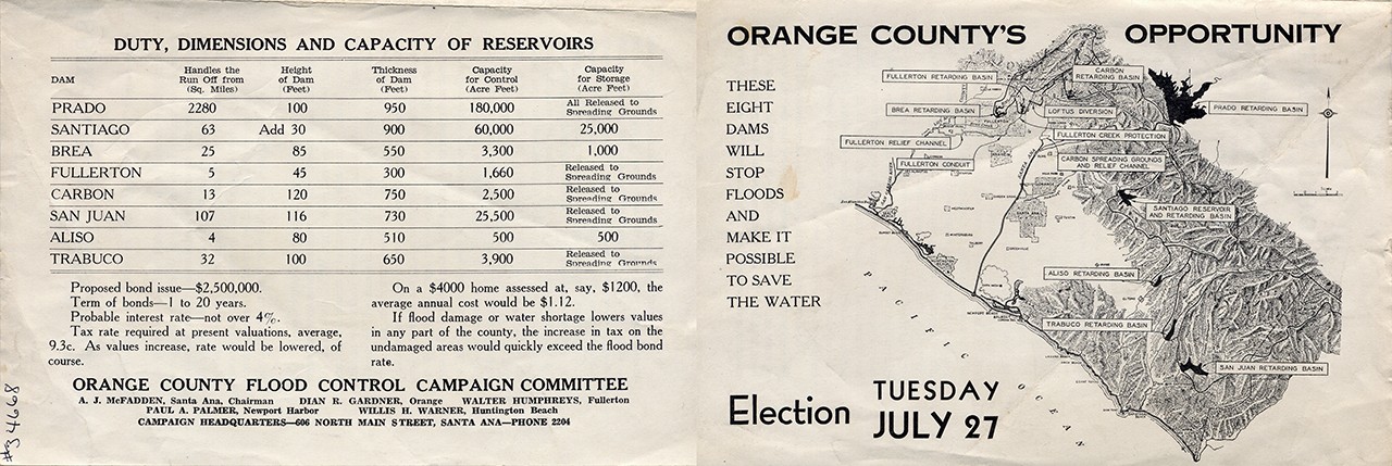 |
The Flood Control Issue in a Nutshell, 1937
Orange County Flood Control Campaign Committee; Santa Ana, California
Ink on paper
34668
Gift of Mr. Weston Walker |
Budding County, Flooding Rivers
Floods affected Orange County with the same degree of regularity and intensity as the rest of the state but became better recorded as the area became more and more populated. The flood of 1862 saw water four feet deep in Anaheim, about four miles from the Santa Ana River. Though the Bowers permanent collection does not have any images from that flood in Orange County, it is host to several images of lesser floods in the early years of the 20th century. One of these came in 1927, the same year that the Orange County Flood Control District (OCFCD) was created by the State Legislature to prevent flooding and to create a system to use excess rainwater for beneficial purposes such as irrigation. The first effort by the OCFCD to pass a bond measure to build a series of dams that would allow the county to better control and direct water during heavy rain events was floated in 1929 and failed by just 410 votes. Had it not failed, then the tragedy of 1938 may have been avoided.

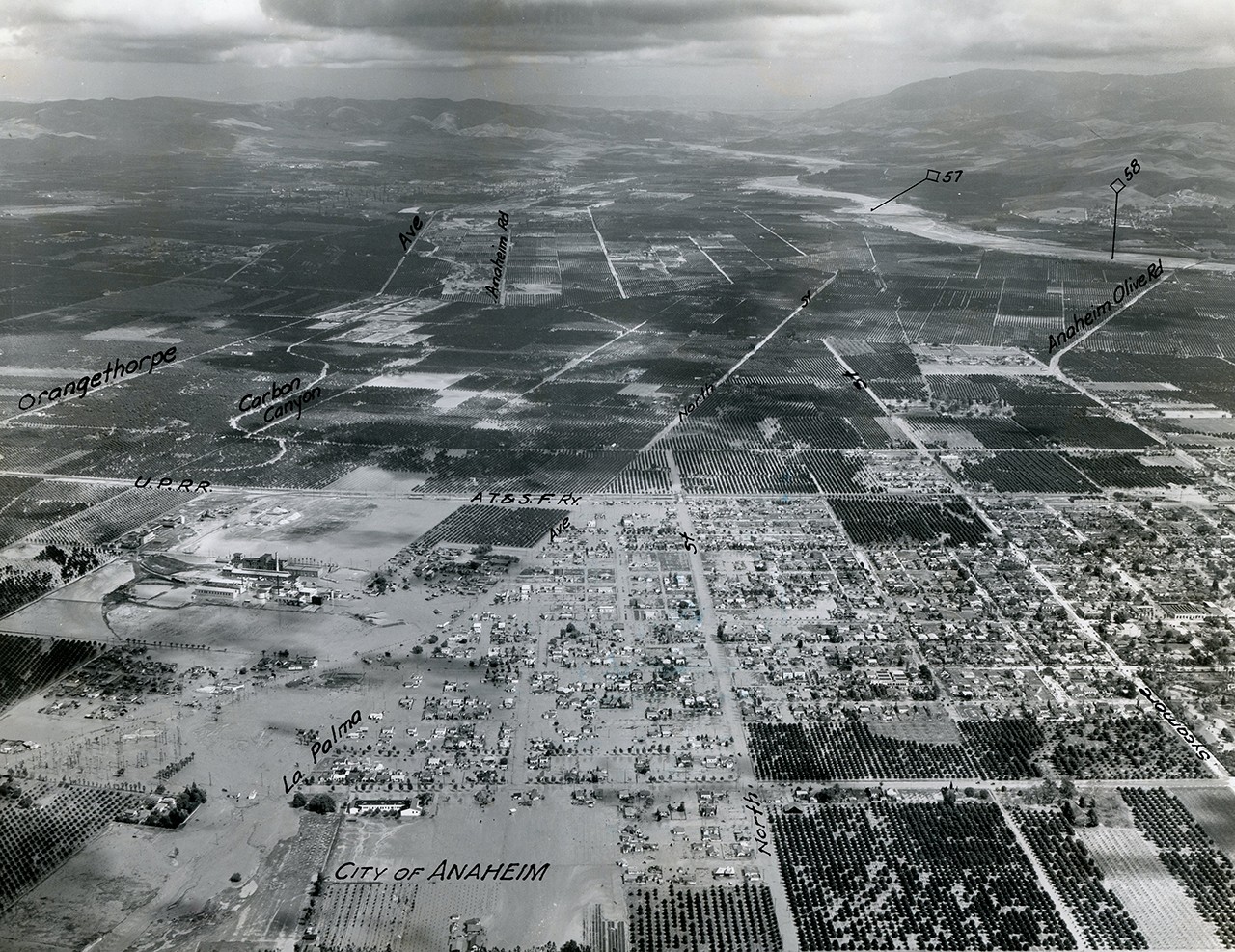 |
Aerial Shot of a Flooded Anaheim, 1938
Fairchild Aerial Surveys; Orange County, California
Photographic print; 10 x 8 in.
34413.44
Gift of Judge Raymond Thompson |
Ark-less in Orange
In 1936 the Federal Government passed the Flood Control Act of 1936 which approved the construction of the Prado, Santiago, Brea, Fullerton, Carbon, San Juan, Aliso, and Trabuco dams. To raise funds for the dams a new bond measure was put on the ballot in July of 1937 that ultimately succeeded. However, construction was not able to commence that year. In late February and early March of 1938, the Los Angeles, San Gabriel, and Santa Ana Rivers simultaneously flooded their banks due to a winter of La Niña rains. These floods left severe damage throughout the southlands. In Orange County alone around 60 people were killed, mostly in the Hispanic neighborhood of Atwood where 43 Hispanic residents were swept away by an eight-foot surge. The vast majority of the Bowers’ photographs of the flood and resulting destruction come from a court case overseen by Judge Raymond Thompson between a local landowner and the OCFCD who he claimed had been negligent in protecting his property. In the years after the flood of 1938, the OCFCD’s project was realized, creating a system of dams and channels which control the release of water during heavy rainfalls and have minimized damage and loss of life even during far heavier rainy seasons than that of 1938.

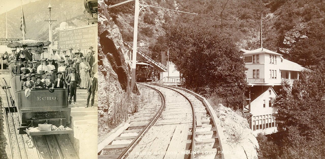 |
Mount Lowe Railway Car, August 1905
Unknown Photographer; Echo Mountain, California
Photographic print; 10 x 7 in.
36626
Gift of Mrs. W. B. Lockett |
Mount Lowe Railway in Rubio Canyon, 1893-1938
Unknown Photographer; Altadena Rubio Canyon, California
Photographic print; 5 1/4 x 8 1/2 in.
2001.54.20
Gift of Cheryl Miller |
Sloughing a Railway
Though lesser victims when weighed against human lives, bridges, roads, and railways have been fighting a losing battle against torrential rains since their inception. One such example of Southern California infrastructure ended by the flood of 1938 was the Mount Lowe Railway, one of three scenic mountain railroads created as a tourist attraction on Echo Mountain and Mount Lowe. The railway was operational from 1893 to 1938 and was the only scenic mountain overhead electric trolley railroad built in the United States. Though it was hardly devoid of issues even in its best years, landslides caused by the flood of 1938 washed the majority of the railway right off the mountain. The eerie, long-abandoned remains of railway tunnels still haunt the mountains to this day.
Text and images may be under copyright. Please contact Collection Department for permission to use. References are available on request. Information subject to change upon further research.


Comments